Tory Island, or simply Tory (officially known by its Irish name Toraigh), is an island 14.5 kilometres (9.0 miles) off the north-west coast of County Donegal, Ireland, and is the most remote inhabited island of Ireland. It is also known in Irish as Oileán Thoraí or, historically, Oileán Thúr Rí. The word Tory comes from the Middle Irish word Tóraidhe which means bandit.
Lying 12km off north Donegal, Tory Island or Toraigh, the most remote of Ireland’s inhabited islands, is a timeless place ruled by its own elected king where people still talk of ‘travelling to Ireland’.
Toraigh’s remoteness has led to the preservation of the traditions and way of life of its resilient and independent people. Their music, dance, song and stories are living expressions of an ancient Gaelic culture. Many of Toraigh’s ancient customs still survive, including the appointment of the island king or Rí Thoraí.
Interesting historical sites include a round tower that once protected monks from Viking raids, the ruins of St Colmcille’s 6th century monastery and the intriguing Tau Cross that suggests early seafaring links to the Coptic Christians of Egypt. The island also boasts an abundance of rare bird life and wild flower species as well as a rich submarine landscape that can be explored through the local dive centre.
Toraigh must be visited if one is to understand why this remote crag holds such an attraction for its inhabitants that they, like their forebears, endure the full fury of the North Atlantic winter for the privilege of living there in summer.
Flora and Fauna
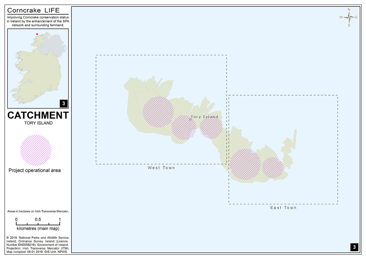
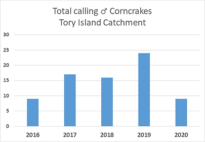
The island is a well-known breeding site for Corncarkes. Over the years, the numbers have fluctuated from a high of 34 calling males in 2003 to a more recent census estimate of ten calling males. Tory is a favored spot for many visitors who wish to see or hear corncrake and there is great potential to enhance habitat on the island for the species. Tory is also famous for arrival on occasion of rare vagrant species of bird from the neartctic. The island is a protected area for many bird species including; Fulmer, Razorbill and Puffin.
Demographics
The table below reports data on Tory Island’s population taken from Discover the Islands of Ireland (Alex Ritsema, Collins Press, 1999) and the census of Ireland.
Language
Irish is the main spoken language on the island, although English is spoken to communicate with visitors. Tory is part of Donegal Irish and Ulster Irish (Gaeilge Uladh) is the main dialect of Ireland. The island is about 5 kilometres (3 miles) long and 1 kilometre (0.6 miles) wide, and 1.38 square miles. The 2016 census recorded a population of 119, a decrease from the 2011 population of 144. The population is divided into four towns – East Town, West Town, Middletown and Urban (Newtown). ).

Geography and Transport
Tory has no airport, but has regular ferry connections from mainland County Donegal. The ferry travels daily all year round. The ferry does not take cars, but holds up to 70 passengers. During the winter months, sea crossings may not be possible due to rough seas – but from November to March, a small 4-seater helicopter runs from Falcarragh to Tory every other Thursday.
The Tory Island ferry is operated by Turasmara and will take you from the fishing harbours at Bunbeg and Magheroarty to the Island on board Tormór, a fully equipped and certified coastal cruiser. The service is licensed by the Department of Marine and is approved and promoted by Tourism Ireland.
w: www.toryislandferry.com or www.toryferry.com
t: 00353 (0)74 9531320
Tourism
Tory Island has a number of historical and mythological sites:
- Dún Bhaloir (Balor’s Fort) is located on the island’s eastern side. This peninsula is surrounded on three sides by 90-metre-high (295-foot) cliffs. Balor’s Fort is accessible only by crossing a narrow isthmus, defended by four earthen embankments.
- An Eochair Mhór (the Big Key) is a long, steep-sided spur jutting from the east side of the peninsula and ending in a crag called An Tor Mór (the Big Rock or the Big Tower). The spur has prominent rocky pinnacles – these are known as ‘Balor’s soldiers’ (Saighdiúirí Bhaloir). They give the spur a ‘toothed’ appearance and contribute to the name, ‘the Big Key’.
- The Wishing Stone is a precipitous flat-topped rock beside the northern cliff-face of Balor’s Fort. Traditionally, a wish is granted to anyone foolhardy enough to step onto the rock, or who succeeds in throwing three stones onto it.
- An Cloigtheach (the Bell Tower) is the largest structure to have survived the destruction of the monastery (see history section above). The round tower was built in the 6th or 7th century.
- The Tau Cross (a t-shaped cross) is believed to date from the 12th century. It is one of only two Tau crosses in Ireland (the other being in Kilnaboy, County Clare).
- Móirsheisear (Grave of the Seven): Móirsheisear, which actually translates as ‘big six’ – a term for seven – is the tomb of seven people, six men and one woman, who drowned when their boat capsized off Scoilt an Mhóirsheisear (the Cleft of the Seven) on the island’s northwest coast. According to local superstition, clay from the woman’s grave has the power to ward off vermin.
- The Lighthouse, standing at the west end of the island, was built between 1828 and 1832 to a design by George Halpin, a noted designer of Irish lighthouses. In April 1990, the lighthouse was automated.
- The Torpedo: A torpedo can be seen midway between An Baile Thiar and An Baile Thoir. It washed ashore during World War II and was defused and erected at its present location.
For more Maps and Tourist Information visit: http://www.oileanthorai.com/
For more information on the Special Protection Area within this catchment, visit the National Parks and Wildlife Services website https://www.npws.ie/protected-sites/spa/004073