Wildlife
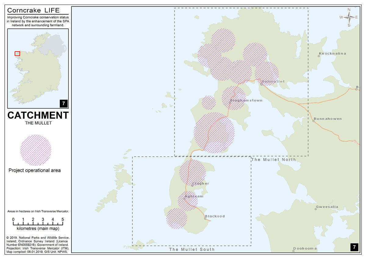
The Mullet Peninsula Special Protection Area comprises three separate areas situated on the Mullet peninsula in Co. Mayo. The peninsula is low-lying and exposed (rarely rising above 20 m) and is mostly underlain by metamorphic schist and gneiss, although the southern tip is granite and rises to 103 m. The three areas that make up the site are located, respectively, 5 km north-west, 2 km west and 15 km south-west of the town of Belmullet.
The main habitat present is grassland, which is managed in a relatively intensive manner. The site is selected as a Special Protection Area (SPA) under the E.U. Birds Directive, of special conservation interest for the following species: Corncrake. The Mullet Peninsula SPA supports a breeding population of Corncrake (5 pairs – five year mean peak between 2003 and 2007, based on records of calling males).
For more information on the Mullet Peninsula Special Area of Conservation, visit the National Parks and Wildlife Services website https://www.npws.ie/protected-sites/sac/000470
Belmullet
Belmullet is in the barony of Erris, located on the northwest coast of Co. Mayo in Ireland and is one of the most westerly points in Europe. For many centuries, the locals have said that the next parish over is New York!
At the four corners of Erris, you’ll find: the Neolithic Céide Fields, the unspoilt wilderness of Ballycroy National Park, the towering cliffs at Ceann Iorrais (Erris Head), and the final resting place of the fabled ‘Children of Lir’ – the island of Inis Gluaire. This part of the Wild Atlantic Way is very accessible. You can reach Belmullet and Erris by flying into Ireland West Airport Knock, from all over Europe. This airport in Co. Mayo is approximately 1½ hours’ drive from Belmullet.
Gaeltacht
Belmullet (Béal an Mhuirthead) is a coastal Gaeltacht town with a population of 1,019 on the Mullet Peninsula in the barony of Erris, County Mayo, Ireland. It is the commercial and cultural heart of the barony of Erris, which has a population of almost 10,000. According to the 2016 census 50% of people in the town were able to speak Irish while only 4% spoke it on a daily basis outside the education system. There are over 1,500 daily Irish speakers in Erris.
Belmullet has a vibrant Irish speaking community, which supports the activities of Irish Language and Cultural Organisations in the county including Comhar Deirbhile, Conradh na Gaeilge and Gnó Mhaigh Eo.
History
The Erris area of North Mayo is rich in folklore, tradition and history and the ancient parish of Kilcommon, which once comprised the whole of ‘mainland’ Erris, was the largest parish in Ireland until its division into the present-day parishes of Kilcommon, Belmullet, Kiltane and Ballycroy. Erris and it’s history are chronicled in many publications wherein Erris people, at home and abroad, can find a deeper knowledge and appreciation of the land of their birth and an awareness and love of their precious Irish and Christian heritage.
- Erris in 1837
- Bangor
- Belmullet
- Binghamstown
- Kilcommon
- Kilmore-Erris
- Extracts from “Mayo – Aspects of its Heritage”
- History Of Belmullet Town
- History Of Glencastle
- Iniskea Islands
- Landlordism In Erris
- Local Placenames
Things to See and Do
Belmullet is the capital of the Gaeltacht (Irish-speaking) region of Erris, an area that offers unspoilt beauty and glorious beaches and is the ideal place for that get away from it all holiday. Erris is famous for its rich fishing waters, and to date thirty nine species of fish have been caught locally. For the golfer Carne Golf Links offers a challenging experience and visitors are welcome.
For those who wish to immerse themselves in Irish culture there are three summer schools in the Erris area. The Erris coastline has an abundance of beautiful uncrowded beaches, some of Blue Flag status ensuring clean water and safety. This EC quality status was awarded to Elly Bay and Mullaghroe, both located on the Mullet Peninsula, south of Belmullet.
Iniskea Islands
Situated on the west coast of the Mullet Peninsula the islands are rich in amazing scenic, rare wild life and are also archaeologically and ecologically sensitive areas. The island is very important to birds; the mute swan, the peregrine and the endangered corncrake are some of the birds that benefit from the peace and protection of the islands. Half of the Irish wintering population of Barnacle geese make the islands their home. The low-lying coasts of the islands are home to large number of grey seal while sharp-eyed visitors can occasionally see dolphins and whales out to sea.
There is also quite a bit of history based on the island back in early Christian times. Saint Colmcille founded a monastery on Inishkea North, in the early Christian period and a purple ink which was used to illuminate the manuscripts was exported from here to other monastic sites. Saint Brendan the navigator had strong links with the island and the remains of monastic settlements that were founded can be still be seen today.
The Inishkeas were home to a thriving fishing community until disaster struck on 28th October 1927, when ten fishermen were lost at sea on that ill-fated night. Only two fishermen survived that disaster and the islands were deserted shortly after. Rusheen, a tidal island to the east of Inishkea South was once the site of a whaling station, set up by the Norwegians in 1907, the remains of which are still evident today. For more on the history of Iniskea visit Ionad Deirbhile Heritage Centre.
Here you will find information on leisure pursuits in the Belmullet area.
Walking
The Erris Head Loop Walk is a 5 km long loop walk. It is part of a countrywide network of high-quality, where the walker can walk spotting spectacular views and discover the rich and varied wildlife of Erris.
The Bangor Trail goes from Newport to Bangor Erris, a distance of 22 miles. The Trail is well sign-posted at both ends and is an exciting challenge to walkers. Mayo County Council has published an excellent guide to the Bangor Trail, which has maps and information in great detail. The book is available in local shops and newsagents.
The Dun Caochain Walks goes through various landscapes such as spectacular cliff scenery, dunes and beaches. These walks stretch westward from Belderrig to Porturlin, Portacloy, Benwee Head, Cornboy and further west to Rossport. Guided or self-guided tours are available with local transport; accommodation and meals all organised.
The Western Way is a major walk developed all along the Western coast starting in Connemara and going all through Mayo and Galway. The route is well documented and well mapped. The Western way continues from Bangor Erris through Sheskin and on into Belderrig and Ballycastle. The book and detailed maps called ‘The Bangor Trail’ is available in all good book stores.
Watersports
Erris is fortunate to have a modern Adventure Centre where Watersports are taught in a safe and secluded environment.
‘UISCE’ is the only centre of its kind in Ireland, mixing adventure sports with Gaelige in a new, exciting and original way of learning both Watersports and Irish.
The teaching media of windsurfing, surfing, canoeing, sailing, pony trekking, swimming and orienteering takes Irish out of the classroom, and gives children a new perspective of the language. In this way Irish itself is being developed by being associated with modern, exciting adventure sports.
Canoeing
The sheltered Elly Bay is perfect for learning Canoeing. Once the basics are mastered, the class then ventures further along the coast to discover new beaches and coves. For the more experienced canoer, the waves of the Atlantic provide ample opportunity to test your skills.
Sailing
The sailing classes are taught in the safe, sheltered bay near the college. This is an ideal place to be introduced to the sport and an even better place once you improve. On successful completion of the course, students receive an ISA Level One Certificate. If students are already at this standard they can progress onward to levels 2 or 3.
Windsurfing Classes
The Windsurfing classes are also taught in the sheltered and safe bay, which is close by to the college. This is an ideal environment to be introduced to the sport, and particularily suitable for more advanced students. Further studying is also available.
For further information, contact:
UISCE, Elly Bay, Clogher, Belmullet, Co. Mayo
Tel: (097) 82111
Accommodation
Miles of golden beaches, rugged Atlantic coastline, heather-clad mountains and natural unspoilt landscapes as far as the eye can see – that’s Belmullet, the jewel in the heart of the Erris peninsula. For one of the best ‘get away from it all’ holiday destinations in Ireland, Belmullet is high on the list of contenders.
A retreat for outdoor enthusiasts, there are numerous healthy activities and pursuits including hill-walking, cycling, horse-riding, boat trips to the islands, sea-angling, lake and river fishing, to name but a few.
Well serviced with shops, pubs, restaurants, bakery, banks and many other amenities, Belmullet is an ideal holiday destination for all age groups and has accommodation choices to cater for all budgets.
Download the Belmullet & Erris Tourism Map here
Attention!
Belmullet & Erris is a Gaeltacht region, which means that our native Irish language is still very much in use here. Most of our road signs are in Irish, which sometimes can be confusing for visitors. Please see here to help you navigate your way through our beautiful Gaeltacht towns and villages.
Placenames & Road Signs/Logainmneacha agus Comhartha Bóthair.
For more Maps and Tourist Information visit: http://visitbelmullet.ie
For more information on the Special Protection Area within this catchment, visit the National Parks and Wildlife Services website https://www.npws.ie/protected-sites/spa/004227