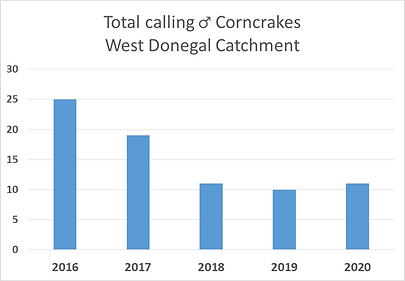
The west Donegal project catchment is characterised by several uninhabited off-shore islands. The corncrakes are a regular feature of the island though numbers have declined somewhat in recent years. One of the main challenges for corncrakes on the islands is a loss of traditional low-intensity farming practices. Where grasslands are left ungrazed or uncut, they soon build up a dense layer of matted and rank vegetation which is unsuitable for corncrakes. The project will work with the local landowners to restore as many grasslands as possible which will not only benefit the corncrake, but wider biodiversity as a whole.
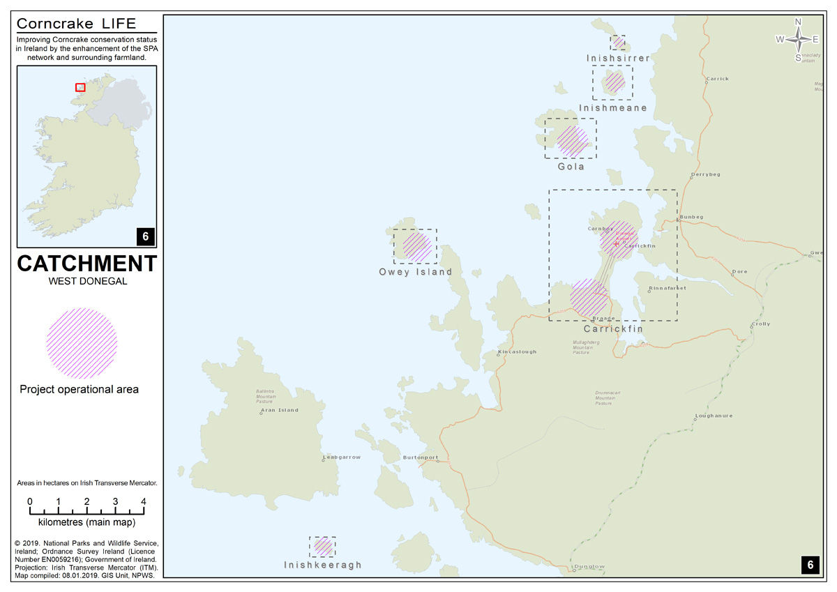
West Donegal Catchment covers an area of 124.53 and consists of 5 islands (Gola, Inismeane, Inishirrer, Owey, Inishkeeragh) as well as the Carrickfinn peninsula.
There is a seasonal ferry service to Gola and Owey is easily accessible by boat or kayak. Inishmeane is seasonally inhabited, Inishirrer is not inhabited. Inishkeeragh has some summer residents. Carrickfinn peninsula has sparsely distributed dwellings and pristine beaches.
Gola Island (Gabhla or Oileán Ghabhla)
Gola Island is 328ha in size, and 34ha. The island is approximately 2km off the coast of Gweedore and 4.8 km from Bunbeg harbour in north-west County Donegal. A lake (Lough Magheranagall, 1.25ha in area) is in the west of the island, barred from the sea by a gravel barrier.
The island terrain is mildly hilly with many bog road and sheep paths.
At present, during the winter the only inhabitants on Gola are animals. Sheep and some shy goats tend to reside along the cliffs.
To the back of the island, seabirds are numerous, with cormorants, shags, razorbills, guillemots as well as the odd passing gannet and skua. At the southern end of the near Port na Crin and the old school house, many shore species of bird can be admired such as the eider, oystercatcher, divers and various species of tern.
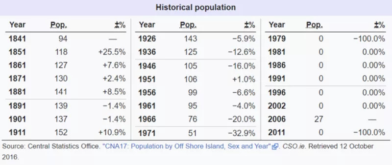
The island was populated up until the mid-1960s. Today many of the buildings on the island are derelict, but several have also been renovated as holiday homes and the island has summer residents. The island terrain is mildly hilly with many bog road and sheep paths. The island is currently grazed by about 30-40 free-roaming sheep.
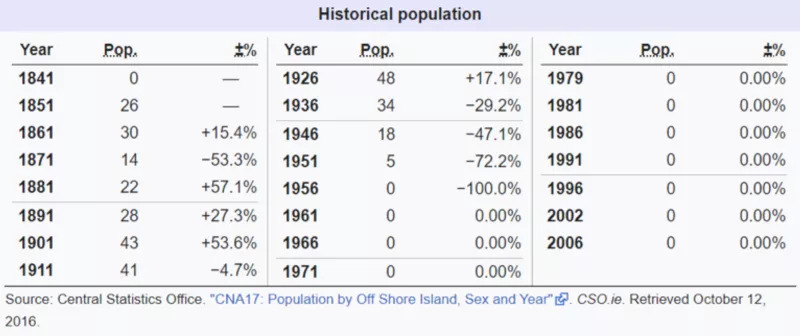
Demographics
The table below reports data on Gola’s population taken from Discover the Islands of Ireland (Alex Ritsema, Collins Press, 1999) and the Census of Ireland.
Inishirrer (Irish: Inis Oirthir, meaning ‘outer island’) is a long, narrow island, about one mile long and one quarter of a mile wide and is the northernmost island in this catchment, lying c. 700m north of Inishmeane and 2.5 km north-west of Gola Island. It is approximately 1 km west of the mainland. Most of the island is covered in heath. A small lake occurs on the island. Corncrakes recorded in recent years were in the southern end of the island, in nettle patches around abandoned buildings. The herb-rich grasslands on Inishirrer are grazed by sheep in the summer.
Demographics
A small community used to live on Inishsirrer in the first part of the 20th century, but today the island is unhabitated and its old buildings are mostly ruined.
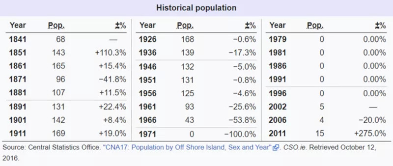
The low-lying island of Inishmeane (Irish: Inis Meáin, meaning ‘middle island’) is a small island and a townland off the coast of Gweedore, County Donegal, Ireland and was once home to a vibrant fishing community. The island has been unpopulated for decades but in recent years some people have started to return. It is situated 1 km off the west Donegal coast, between Inishsirrer to the north and Gola Island to the southwest. The island was abandoned in the mid-1960s and the handful of houses are now inhabited in summer only. Corncrake habitat is dominant in the centre of the island, within old fields bound by old dry-stone walls and grass-covered banks. The island has not been grazed in approximately 25 years.
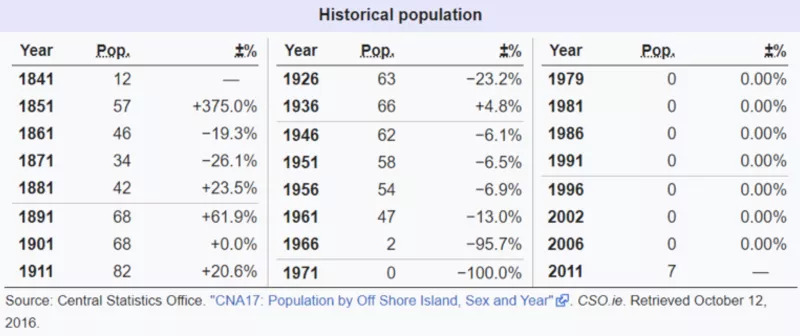
Demographics
The table below reports data on Inishmeane’s population taken from Discover the Islands of Ireland (Alex Ritsema, Collins Press, 1999) and the Census of Ireland.
Inishkeeragh (Inis Caorach) which in Irish means ‘Sheep or Ewe Island’, is part of Illancrone and Inishkeeragh SPA, which is designated for the following species of conservation interest: Barnacle Goose, Common Tern (Sterna hirundo), Arctic Tern (Sterna paradisaea) and Little Tern (Sterna albifrons). Inishkeeragh is a flat, grassy island surrounded by extensive intertidal rocks, just south of Aranmore Island and 8km west of the town of Dungloe in Co. Donegal. Relative to the other islands that are in the catchment, Inishkeeragh is approximately 17 km south west of Gola, Inishmeane and Inishirrer, and about 11km south-west of Owey island. Inishkeeragh is a medium-sized, low-lying island extending over 19 ha.
The island was inhabited until the 1950s and today only a handful of houses on the island are inhabited in summer. The island has a distinctive rectilinear field pattern surrounded by stone walls. These fields have now reverted to rough grassland, grazed by 5-10 sheep throughout the year.
Owey Island (Irish: Uaigh, meaning ‘Cave’) extends over 120 ha and lies just a short distance off Cruit Island, near Kincasslagh in West County Donegal. It is 11 km north-east of Inishkeeragh and approximately 6-8 km south-west of Gola, Inishmeane and Inishirrer. The island was last inhabited full time in 1974 and it now has a small seasonal population. The only source of fresh water is the stream that runs in a west-east direction through the village.
Demographics
Owey Island was full-time inhabited up to the mid-1970s. Later on it only had part-time residents, mainly at summer. Most of them own old cottages inherited by ancestors who used to permanently live in the island.